- Recent Updates
- Colpoy's Bay
- Colpoy's Bay Introduction
- Spragge's Hill
- The Kalbfleisch House
- The Kalbfleisch Dock
- The Kalbfleisch Marina
- Whicher's Sawmill
- The Wrecks Near Whicher's Mill
- Frame's Falls and John Wood's Grist Mill
- Albemarle Street
- Hughenden and Whicher's Store
- The Community Hall
- The Forest Home Hotel
- The Colpoy's Bay Schoolhouse
- The Colpoy's Bay Church
- Edgehill Cemetery
- Colpoy's Bay From the Air
- A Glimpse of the Past
- Wiarton
- Berford Street
- Berford St. Part 2
- Berford St. Part 3
- Wiarton Harbour
- Bluewater Beach
- Caframo Ltd. and Wiarton Cement Works
- Wiarton Beet Sugar Factory
- Wiarton's Hotels
- Wiarton's Schools
- Wiarton's Banks
- Grand Trunk Railway Station
- The Wiarton Fish House
- The Wiarton Fish Hatchery
- Wiarton's Berford Theatre
- The Wiarton Woolen Mills
- Wiarton's Furniture Industry
- Wiarton's Hospital
- Wiarton's War Memorial
- Wiarton's Town Hall
- Wiarton's Newspapers
- Wiarton's Grist & Flour Mills
- Wiarton's Sawmill Industry
- Wiarton's Gateway
- Connecting Passages
(Links) - Present-day Map
of Colpoy's Bay - Colpoy's Bay
Lot Map (1870) 
Wiarton Timeline- Present-day Map
of Wiarton - Bibliography
- About the Author
- Site Map
(use if menu doesn't work) - Tell me your impressions!
Colpoy's Bay from the Air
Thanks to the National
Air Photo Library, I've been able to assemble a series of aerial photographs
of the core of Colpoy's Bay. You can zoom in and scroll around each image below. You will also find accompanying text with some interesting notes below each image.
Colpoy's Bay circa 1938
Figure 15A is relatively early in the library's
archives, and as such has a much lower resolution than later images.
Nonetheless, it gives a spectacular view of the village in 1938.
Immediately noticeable is the treed shoreline with very few buildings compared
to later years. Whicher's Sawmill continues to operate and the two
old barges, The Lothair (right) and Edward S. Pease (left)
are still pretty much in the same condition as when they were placed there
some 40 years previously (specifically, one can still see the hull with
superstructure or cabins on top). The full length of the Kalbfleisch
Dock is discernable with several boats tied up, probably constructed by
Edwin Kalbfleisch himself. Above that, partly hidden by trees, is
the Kalbfleish House and several one-room cabins for use by lodgers
and customers paying for fishing/tourist expeditions on the bay.
The next building visible to the left of the Kalbfleisch House is Edwin
Kalbfleisch's former workshop, part of which was Rev. Ludwick Kribs' original
log home, one of the oldest buildings in the village. Although the
sidestreets (Urban, Edgar and Martha streets) were envisioned back in 1870,
they are nowhere to be seen in 1938. The curve in Kribs' Road is
obvious, marking where the concession was redirected to meet the former driveway
of Kribs'/Wood's gristmill. The curve in Albemarle Street is much
more angular than it is today. On the left hand side of Albemarle
St. about half way between the curve and Kribs' Rd. you can see the Women's
Institute community hall (then 11 years old) with skating rink (later a tennis
court) and just above that one can also make out the scar on the ground
where the Forest Home Hotel burned down only 4 years previously.
Notice the road along the shore at the far right of the picture, Mallory
Beach Rd., is still only a thin dirt track. In fact, all of Albemarle
St., the main road in Colpoy's Bay, was first paved at about the time of this photo.
Colpoy's Bay circa 1950
Image 15B is of significantly higher resolution than the one taken in 1938. The full Kalbfleisch dock,
the one-room cabins next to the Kalbfleisch House and the privately financed
sidewalk (made of slabs of local limestone) running along in front of the
house are all clearly visible. Whicher's Mill is still running, with
piles of lumber all around. The Lothair and Edward S. Pease
have, by this point, severely deteriorated. Just past the curve in
Albemarle St. and above Mallory Beach Rd. is the Pruder house (now gone).
Mallory Beach Rd. itself is more defined, the houses down along the shore
having been developed in 1946. The worn down area of the skating
rink behind the Women's Institute is now gone, although the path of what was once known as Brown St., and the foundation of the Forest Home Hotel are still
visible just above the community hall. At the top right of this photo,
one can see the two former homes of the McDonagh family, the entrance to
Edgehill cemetery (with pedestals on each side) and, at the very top, the
original home of Henry Kalbfleisch, occupied before he bought the Kalbfleisch
House along the shore (Kalbfleisch's original lot was eventually absorbed by the cemetery). Hughenden,
the Whicher home, is visible near the top left of the photo.
Colpoy's Bay circa 1952
Only two years after the previous photo,
there are some notable changes. Most obvious is the construction
of Edgar St. (some 80 years after it's original planning). The original
Kalbfleisch dock is in disrepair, most likely due to the winter iceflows.
The Kalbfleisch barn is clearly visible just above and to the
left of the house. Whicher's Mill is still standing, although the
piles of lumber have largely disappeared. The mill would stand only
two years more before burning down. The Pruder house still stands
just past the curve in Albemarle St. (on the right - replaced in 1965).
Colpoy's Bay circa 1989
This is the most recent and highest resolution aerial photograph I've included. It offers an excellent view of specific buildings, especially since it was taken during spring when there were no leaves on the trees. In the 36 years that passed since the previous photo, the most glaring change is the boom in construction. Many more cottages have been built, due to the surge in summer residents. This prompted the laying of both Urban and Martha Streets (first planned in 1870). In this photo, the Kalbfleisch house is clearly visible, out from under the shroud of trees that once covered it. The driveshed and garage are just above. The original barn is now gone, having collapsed in 1963. The three small one-room cottages that stood to the right of the Kalbfleisch House were merged into one cottage in the 1960s. The stone sidewalk that once ran in front of the Kalbfleisch House and nearby residences is gone. It was taken up in the 1960s to make room for a wider road and drainage ditch. (Slabs of the sidewalk can still be found throughout the village, for example at the Kalbfleisch House and Whicher's Store.) The home of Fred Kalbfleisch is next door to the Kalbfleisch House on the left, built by him based on two small cottages in the late 1950s. Just below and to the left is the site of his former workshop (including Ludwick Kribs' log home) which were torn down only a year or so previously. A home now sits on the site. The sunken barges and dock once making up the Kalbfleisch marina are visible, mostly beneath the surface of the water. Notably, Whicher's Mill is now gone, with an underwater-welding barge now "parked" in its place. The remains of the Mill are just discernable, including the flywheel. The old Pruder house just around the corner on the right side of Albemarle St. is now gone, replaced in 1965. The Women's Institute is clearly visible, along with the former path of Brown St. There is no longer any sign of the Forest Home Hotel. The Whicher Store still stands at the corner of Albemarle and Kribs' Rd., but ceased operations in 1970, 93 years after it was started by William Bell. No general store has operated in the village since. At the top right of the photo, the entrance to the cemetery is visible, marked by stone pedestals. The original Kalbfleisch house is now gone. Hughenden, the Whicher home with its numerous additions, is near the top left of the picture.
Figure 15E is an excellent colour aerial photo of the shoreline taken sometime around 2001. At the
bottom right is the main wharf, once stacked high with lumber from Whicher's
Mill. Nearby is the mouth of Colpoy's Creek.To the left of that is
the former site of Whicher's Mill, including the two surviving planing
mill buildings (one of which served as the local flea market during the 1970s
and 80s). Below those two buidings you can see the wrecks of the
Edward S. Pease (left) and the Lothair (right) as well as the underwater-welding barge sitting where the mill once stood. The green shallows
of the bay shoreline drop off dramatically into the dark blue depths not
far beyond the wrecks. Up above the former flea market is the entrance
of Edgar Street. Further down the road you can see the remains of
the Kalbfleisch Marina (including the two scows and the partially submerged stone base of the original dock).
Above that is the Kalbfleisch House.
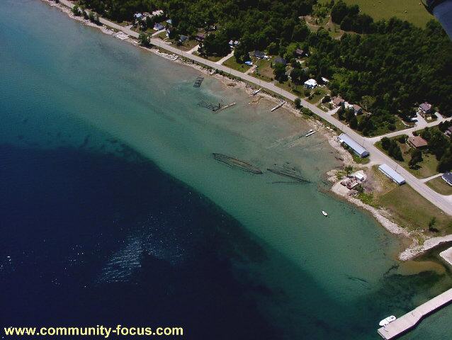
Figure 15E: An aerial view of the eastern shoreline of Colpoy's Bay
village (around 2001)